Western Heritage’s geomatics department specializes in the detailed mapping of landcover and landscapes, as well as applying and interpreting other data sets across these landscapes. Detailed maps and reports can be tailored to your project needs to include all relevant information from digital terrain models to mapping infrastructure.
Our geomatics services can be used alone to provide answers and data for specific problems, or utilized as part of our extensive heritage and cultural management services. Western Heritage has provided geomatics services to clients around the world, from local, regional and national clients to international governments and agencies.
Environmental Footprint Monitoring
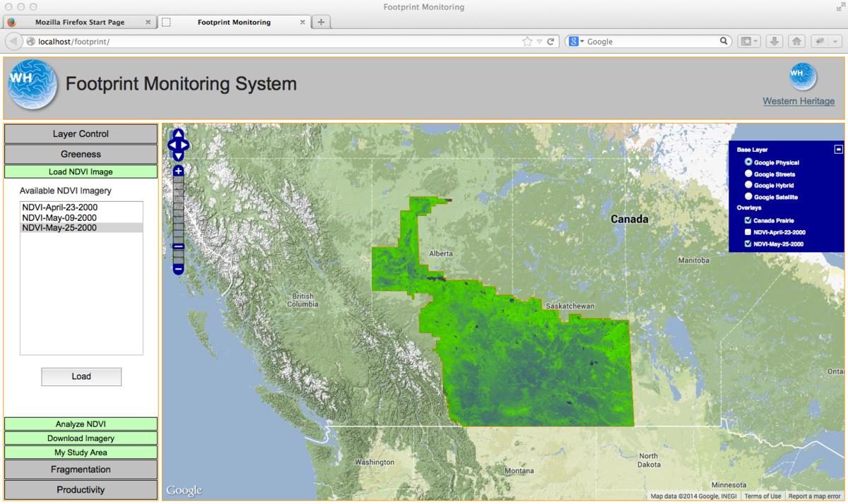
Accurate and effective measurement and reporting of environmental effects is crucial in resource development. In addition to being a key component of sustainable development strategy, it is an important tool for communicating an organizations commitment to corporate social and environmental responsibility.”
The Western Heritage Environmental Footprint Monitoring service provides organizations with a management tool to assist in the monitoring and reporting of environmental health. The service utilizes satellite imagery and remote sensing techniques to generate valuable information about the health, growth, and productivity of vegetation in a project area. The service is perfect for monitoring reclamation areas in the mining and oil and gas sectors, as well as other project areas where vegetation health is a critical factor.
Benefits:
- Generate valuable information related to vegetation and environmental health
- Verify reclamation and project area environmental goals
- Satellite images provide a visual reference to support data
- Provides “big picture” analysis of entire project area, which offers more information than individual soil tests alone
- Helps focus ground testing on areas of highest interest
- Ability to “look back” using archival images to compare project area footprint and health pre, during, and post- development
- Web based service provides constant access to information and ability to generate reports in-house and on demand
See more at: footprintmonitoring.com
Landcover Mapping
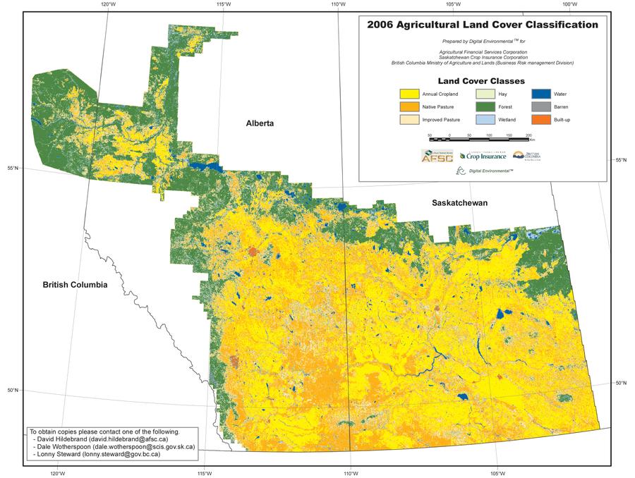
Landcover maps provide a simplified, accurate picture of the surface of your study area.
Maps are specifically tailored to the needs of our clients. For example, if we are mapping pasture land, any towns might be identified as “built up” areas. If the maps are for surface hydrology, we might remap towns as “pervious” or “impervious.”
Western Heritage has provided landcover maps for many applications, ranging in size from several square kilometers to several provinces.
One powerful application is change analysis – using multi-date imagery, we can accurately measure the cumulative impacts of development on specific cover types.
Our Landcover services include:
- Defining cover types (including accuracy measures)
- Selecting appropriate imagery sources
- Completing the mapping and accuracy assessments
Remote Sensing
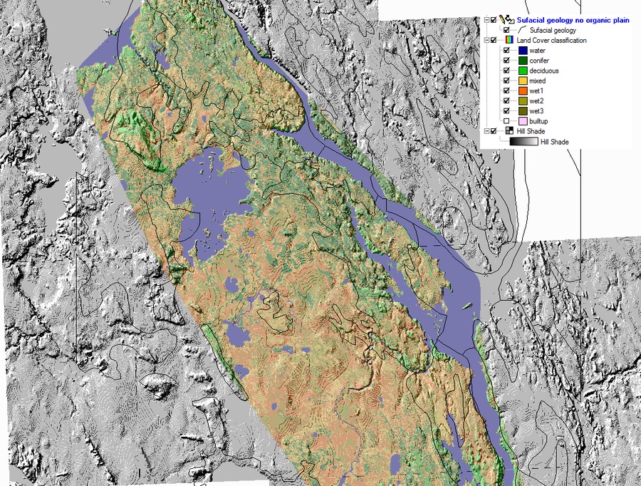
Remote sensing is the science of acquiring information from satellite- or aircraft-mounted sensors. Remote sensing can yield information about the Earth’s surface, atmosphere and properties.
Remote sensing has traditionally relied on pixel-based classifiers.
Western Heritage specializes in object-oriented classifications (with the benefit of rigorous statistical models).
With our models, Western Heritage can provide information for a wide range of environmental applications.
GIS/Modeling
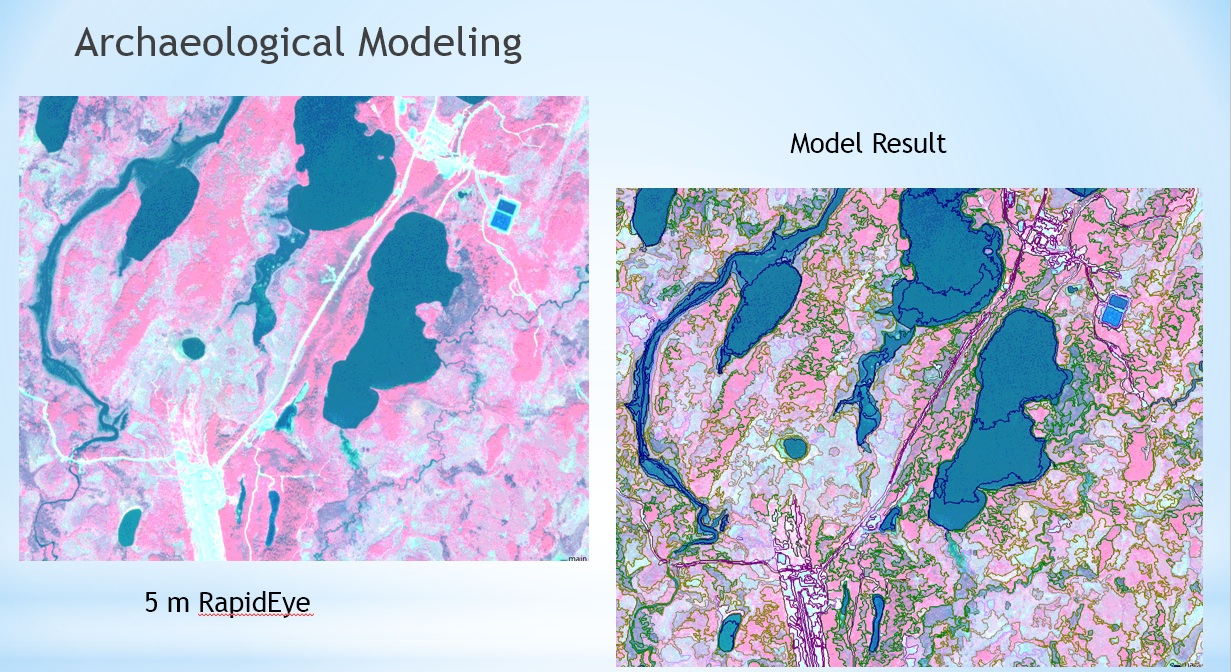
Western Heritage is a pioneer in the development and use of GIS in archaeology.
We work with a wide range of GIS applications and data formats to create maps, diagrams and databases. We can accept geographical data of any kind, and render your results quickly and accurately.
Our experts use GIS to visualize and record data from archaeological, historical and traditional sites for interpretation purposes, or to predict where sites may be located.
We can predict the location of heritage sites by analyzing various aspects of an area’s geography – position on a landform, soil type, proximity to water, ecological characteristics and more. This is the essence of Heritage Potential Modelling.
We have completed numerous Heritage Potential Modeling studies. Tools and techniques have improved over the decades, allowing us to develop progressively better models.
We will continue to develop new generations of models as new methods and data become available.
Data Extraction
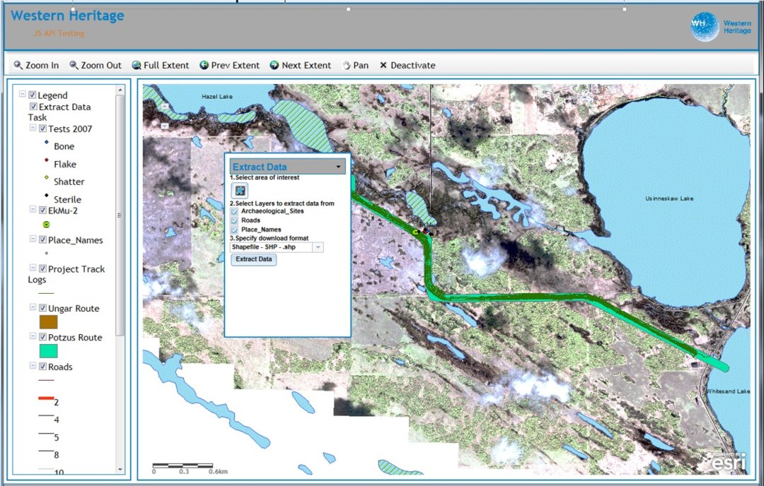
Aerial and satellite images contain large volumes of raw data. The task of extracting this data can be a science unto itself.
Much of the time, information is extracted through the process of classification. At times, with certain image sources, we can extract pixel information (e.g. Modis surface temperature data).
Extracting information can pose numerous challenges. While multispectral information is rich, it can be difficult to extract just the information you need. Imagery needs to be corrected for atmospheric effects and to a common scale (usually radiance for optical satellites, and decibels for microwave satellites).
Our experts can work with you to select the correct data source, normalize the imagery once received, and extract only the information you need.

OFITEAT and Western Heritage are pleased to announce a partnership to provide environmental mapping and monitoring services to our customers worldwide. With more than 45 years of combined experience, we provide valuable information for projects where health and productivity of the environment are of utmost importance.